Refuge du Col-du-Palet, July 13, 2016--
I WOKE UP a little after six and looked through the window above the foot of my bed: a grey morning, but not raining. The firs are grey against a grey sky.
We eat the usual refuge breakfast; then pack up and sack up and out the door, 8:20 am. We are in the valley floor of a national park, the Parc du Vanoise, and at first the trail is manicured, ascending gently on dirt, grass, and occasionally gravel paths, often signposted, with a "nature path" branching off at one point, for those who want placards explaining the ggeology, flora, and fauna.
I am often among those people, but not on this trip: there's no time, and besides I am with three others, and aware of their interests. But mostly there's no time: je mefie les temps, I don't trust this weather. It could begin to rain at any moment. In fact, I've left the rain cover on my backpack.
The last ttime I walked this stage, eight years ago, it took me six hours. Of course we'd started off from Rosuel at one in the afternoon, having climbed up there from Landry, 800 meters lower, and having stopped at Rosuel for lunch. I didn't take that into consideration: I'm eight years older, and slower on the ascents; this is likely to take at least six hours, and who knows what the weather will be. Clouds and mists ccontinually blow through the gaps in the mountains on either side.
We begin in open fields, aware of the rush of water; the Ponturin torrent on our left fed, partly, by three waterfalls chuting down the opposite wall of this valley.

Looking back toward Rosuel
Soon we are in forest, close and comforting, mostly larch trees around us. Our path is packed dirt fleckeed with stones, mostly about the size of my foot, sometimes larger. Kees is usually ahead, and occasionally waits for us; Curt goes next, then either Jim or me. I find the altitude increasingly problematic when climbing like this.

From the forest we emerge into open country, much of itt covered with vegetation — there has been no grazing here just yet. At one point Kees points out some sorrel: Chew a leaf of this, he says; it counters thirst. I try it: he's right.
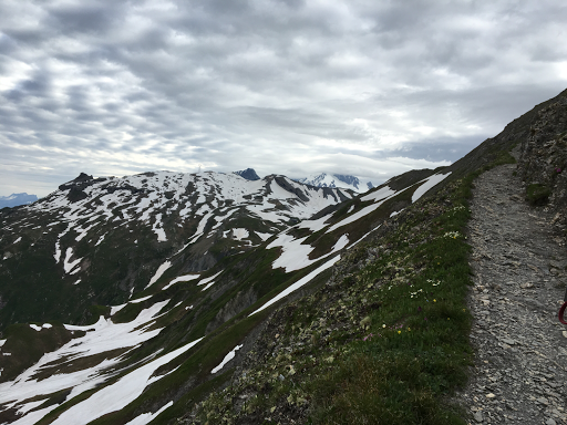
We cross the Ponturin on a wooden footbridge. Around us fairly large stones and boulders lie scattered; limestone brought by glacier down from higher nearby mountaiins. We are climbiing a seris of four or five huge steps, plans or "flats" of rubble, I suppose, left by successive glaciations, converted over the millenia into flat alpages: rock, gravel, soil, grasses, flowers.

You walk fairly easily across one of these plans, occasionally negotiating marshy areas or stepping across freshets; then you climb a hundred meters or more on a stony dirt trail, often worn so deep you have trouble moving one shoe past the other, to the next.
At a certain point we pass a stone chalet. A sign over the door warns that it is private, and a function, somehow, of the Park. The top half of a Dutch door is open, and a discreet glance inside reveals a nicely made-up interior. Walking past we meet a middle-aged woman sitting in the sun, now, on a stone wall; clearly she lives here.

And nearby there are milk-cows: first one with a six-month-old bull calf; then five or six more; then, in the distance, a herd of eighty or so, and a man walking with two border collies and a white dog that may be an Australian mix. And two grey donkeys among them, with their characteristic shoulder stripes.

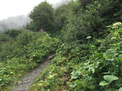
We're in rhododendron country now. At first we see isolated plants blooming bravely against rock or grass; then there's a whole hillside, the sun suddenly opening clouds to shine through them for just a moment. And then you see the entire slope is covered with them, the bushes almost knee-high, all of them in luxurious bloom, surely half a mile of rhododendrons cascading down the hillside.
But by now we've climbed only halfway to the col; it's gettting chilly; I'm getting hungry and thinking about the "picnic" lunch the Refuge de Rosuel had sold me. A while back I stopped long enough to put my sack rain cover away, stowing things properly in my backpack and making my waterbottle accessible; but I don't think it advisable to stop any more; I don't trust the weather; there are surely snow patches ahead to negotiate.; and before them there are tricky water-crossings to manage.

We continue to cllimb. A refuge, Entre-le-Lac, is visible below us, next to a good-sized grey-green lake. We pass another private chalet, no more than sixteen feet square, with a covered area like a low carport (though no car could drive up here!) bearing a sign inviting ramblers to take refuge in case of bad weather but respect the property please.
We cotinue to walk uphill, more gradually now, throughh a defile I suppose you would call it, the Plan de la Grassaz. But we are higher and snow lies on the ground, covering the trail at times, sometimes only a short way, sometimes up to eighty paces. And the paces are short: left right left right the boot drives into the snow to anchor you against falling to the side, in which case you risk a glissade sliding down the slope, inevvitably into often sharp rock.

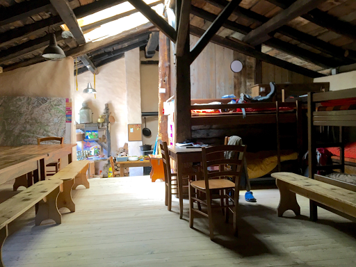
We notice a sign noting our refuge ↑is twenty minutes away. This cannot be true; it's only a little past noon. But after negotiating a couple more snow patches there it is, a familiar roofline, and the welcoming refuge. We take off our packs, lean sticks against yhe wall, and enter a snug dining room, six tables each seating eight, a small stove in one corner, a kitchen beyond.
I want only a bottle or two of carbonated water, which they make on site from the fine glacial water of the area. We lay our sheets out in the dortoir in an adjacent building. Though its snug in the dining room, it's just above freezing outside.
July 13, 2016: 12 km; ↑1000 m; 4:10.