Walks and hikes in Europe and California, posted sporadically as they happen… or as I reflect on them…

Wednesday, June 26, 2013

Alps, 2013, 7: An Easy Day

Bramans, June 26, 2013 —

WE SET OUT southwards from Lanslebourg on a fine cool morning, down the Route des Petits Bonheurs, for an easy day's hike, mostly a very gradual descent, to Bramans, our only problem a little hunger: we had neglected to pack any food, and nothing was open en route — we've discovered this is dead season in the Maurienne, until 1 July; and furthermore the grocery store here in Bramans closes on Wednesdays. 


The Route des Petits Bonheurs — "small pleasures," literally; French has a saying that life is made of small pleasures; I like the implication of modest, everyday, randomly appearing little moments of satisfaction — the Route des Petits Bonheurs is a dirt road, a little gravelly in some places, hard polished clay in others, winding a few miles through forest and field on benchland above the left bank of the rushing Arc river. There are a few uphills, but in general today's walk — you can hardly call it a hike — descends gently to Bramans. 

Five years ago I made this same walk, and wrote

In an hour and a half or so our forest road led us to yet another vieux village of stone-roofed buildings, Termignon, where we stopped for tea, and then to Sollières-l’Enverse, where a handsome, recently built museum of archaeology enlightened us as to the history (and prehistory!) of this once-remote valley…

But one reason I'm repeating the walk is to see how things have changed, and alas, they have, and not always for the better. Termignon's old village is now dominated by the huge bland condominiums and chairlifts of a modern ski-station. Yesterday, walking this same stretch in the other direction, we went into Termignon in search of tea, and found nothing open. Today we simply bypassed it.

We did stop in Sollières, where we made use of the little museum and talked a bit to the archéologue, who had interesting things to say about the two tribes of Neolithic people living in these valleys before the time of the Romans; but we didn't linger. 

South of Sollières we took the paved road past the airstrip, where a snazzy little airplane sat parked, and then walked through the fields of flowers, some of which had recently been mowed for hay.


We hit Bramans about two o'clock and took a room in the one hotel. The hotelkeep confirmed our impression of the independence of these Savoyards, many of whom still resent the rigged election that forced them to become part of France, 140 years ago or so. Although I've yet to find anyone who speaks Italian in the shoos, cafes, or even hotels, the natives here have more in common, he assures me, with the Italian mentalité than the French, are more likely to visit Torino, when they want a big city, than Lyons. 

We are now two weeks ahead of the schedule I followed five years ago, thanks to skipping the too snowy North, and of course the season itself is a little behind. Still, I think we'll be okay from here on. I called the refuge at Mt. Thabor to ask about conditions: there is a little snow, I'm told, but no problems.

So we'll walk slowly to Modane today, spend the night there, then take the bus to Chiomonte and Susa on Friday, for I too am drawn to Italy. Sunday we'll resume serious hiking with the hard climb to Thabor. I look forward to it!


Alps, 2013, 6: A Difficult Day

Hotel Vielle Poste, Lanslebourg, June 25, 2013 —

A difficult day. Up about seven, overcast, cool. Nice breakfast: café au lait, bread, two jellies and honey, applesauce in plastic, yogurt, orange juice. Very nice place, and pleasant woman. We settled up, admired the donkey and her foal, then we walked up to the main road, which gave us a nice view back toward the west. 


The main road took us up to a spot touching our GR5 to Lanslebourg, but balissage was often missing, and twice we were tempted the wrong way, resulting in long difficult climbs we needn't have made, up at least 1000 feet, then back down, and finally bushwhacking by map and compass on occasionally dodgy paths until we finally came out onto forest roads. 


Oh well, we got to Lanslebourg just in time to claim our room, the last in town, in a strange hotel run by Danes. Attic room; can't stand up, inadequate shower, etc. 

Dinner at a favorite place, Relais de 2 Cols, but Lindsey is finally right, it has changed direction and is not remotely the same. 

Tomorrow per Stefan's suggestion we retrace steps toward Modane, taking two days — though so far I can't find accommodations: I suspect bicycle race is conflicting. Then to valSusa, giving Mt Thabor snows time to melt, I hope, and on. 

Alps, 2013, 5: A Day on the Train

Villarodin-Bourget, June 24, 2013

We were up at seven, waiting for breakfast at eight: bread, croissant, nice plum jam, orange juice, an underripe nectarine, café au lait. Then we packed, settled accounts, and stepped out onto the drizzly street toward the main street where we hoped a bus would appear to take us to Thonon. We stopped at a sporting goods store, where I bought a Bic to light the next candle, and a pharmacy, for some hand gel, and then the bus did appear, and we rode it for an hour through beautiful Savoyard country: pastures full of flowers, forests, always, beyond, the mountains. 


We were in Thonon about 11:30 and stopped into a café for a coffee and to watch people. Then we got on our train, which took us to Bellegarde. There we changed to the Grenoble train. At Chambéry, though, where we were supposes to change trains, a group of young people with bicycles and backpacks rushed into the coach, detaining us on our way out, and the doors closed irreversibly just as we got to them; the train started up, and we were trapped. 

The conductor showed up and I explained what had happened. He made an annotation on our ticket and told us to get off at the next stop, half an hour away, and take the next train back to Montmelian where we would catch a train to Modane. There was no better solution. We arrived in Modane an hour later than planned, to find the restaurants all close on Mondays, all but one rather seedy bar wrun by a frazzled, good-natured young woman who I kept amused. (I'm getting by in my version of French; not many I've encountered so far speak English.) you can read about dinner on the blog. We then took a taxi to our night's stay, an apartment in Villarodin-Bourget, very nice and cheap even with the taxi fare.

Monday, June 24, 2013

Alps, 2013, 4: Chalet de Bise to La Chapelle d'Abondance


The Chalet de Bise, early morning


June 22, 2013: We were up about 5:45; the skies overcast — it had rained a bit, though I hadn't noticed; I'd slept well, only noting once someone had got up during the night. Daniel gave us some instant coffee  and a pan of hot water, then quickly finished his breakfast and was away by 6:15, after suggesting he'd see us tonight, and suddenly popping back in to take my photo, of all things. A very nice guy. (Yesterday he'd said he'd be in Nice in twenty days. I'm not so sure. But he's an experienced randonneur, preferring the Pyrenees.)

Breakfast: apricot, walnut, sausage from our packs, and Daniel's coffee. I wasn't hungry, but eating brings appetite. We washed up as best we could at the trough and hit the trail about 8:00. The climb was hard, because the trail was frequently covered by snow, more often by dirt, rocks, and vegetation the snow had brought down over it. 


Still we made the Pas de la Bosse in ninety minutes, fairly good time, and rested there ten minutes. The descent on the otherside was easier — no snow, though mud, and occasional patches of debris. 


In an hour or so we came to a "chalet," a stone building formerly used by shepherds, recently re-roofed for more modern use. A man drove up on a jeep apparently to check the temporary electric fencing, the condition of the grass, etc. — the cows will soon be moving up here. The slopes are full of flowers, ranunculus, buttercups, gentians, those tiny blue ones. Many butterflies, too. 


Then the trail plunged into forest, still descending precipitously. (We were dropping from 1816 to 1021 meters.) Lots of birdsong. At one point a pond under trees, those beautiful Abondance cows cooling off, their bells overwhelming the birdsong. 


Then we crossed the paved road to La Chapelle to take the nature trail down along the ruisseau de Séchen, gurgling gently and providing new kinds of flowers for us. Before long we were in town,where we took a room demi-pension in a nice family old-style hotel, le Vieux Moulin. It will be very nice after last night's primitive accommodations. 

Tonight I hope to get information on the snow conditions. We may have to bail on the northern half of this walk, and go somehow to Modane. I'll let you know…

Sunday, June 23, 2013

Alps, 2013, 3: Chevenoz to Chalet de Bise

 
January 22, 2013—

Up about 6.30 after a solid night's sleep. A fine clear morning; river loud but finches and blackbirds calling above it. The cat was already back on sentinel duty in the "lawn" carved out of the meadow — but breakfast is not served until quarter past eight! We discuss the day with the Dutch couple, and he reserves beds for us as well as themselves at the refuge atop the Dent d'Oche. We're eager to hit the trail, but must get off to a late start, at 8:45. 


It takes a half hour to walk from our gîte to Crêt, where we join the GR5 . the Dutch couple is ahead of us, walking steadily but deliberately. When we break out of forest the views are superb, but we hardly stop to enjoy them: we have a day's work today. At 10:30 we take ten or fifteen minutes to rest: the Dutch are long out of sight.


The first part of the day is very difficult: steep, often muddy, long. I note the times in the guidebook and will retrieve them later. By noon we've reached the col near Mont Baron and it's clear the Dent d'Oche is an ambitious goal: we decide on Chalets de Bise instead. At 1:45 we reach a table d'orientation, and have a conversation with two French couples, petit marcheurs as they modestly say, up  from Bernex, where I'd begun this walk five years ago, to admire the view of Mont Blanc, coyly peeking through mists. 

The guidebook suggested it would take three and a half hours to get here: it's taken us four and a half, not counting the half hour's walk from our gîte. We've climbed nine hundred meters, about three thousand feet. I telephone the refuge at Dent d'Oche and regretfully cancel our reservation. 

By half-past three we've reached the beautiful Lacs d'Oche, and I begin to realize how different this season is. I was here five years ago to the day: there was no snow to beseen, and the lakes were a brilliant green. Today they, and later the even more spectacular Lac de Dechon, are quite frozen:


A fair amount of snow impedes our progress after the Oche junction. We are overtaken by a quick hiker, Daniel: at first I think he's profited from our foot-breaks in the snow, but soon realize it's his technique makes him fast: light on his feet, he skips over the snow where we dig in. At the Col des Portes-d'Oche Daniel has suddenly stopped, transfixed: he's sighted a bouquetin, an ibex, which stands it's ground calmly. 

Not wild?, he asks, and I explain they've been protected from hunting for decades, and have lost their fear of humans. I'm a little disappointed to find only six or eight of them scattered about, where five years ago there'd been a sizable herd — but it's later in the day this time; maybe that's it. 

Still the snow seems treacherous on steep traverses. Then we meets another, lightly clad, running from Bise down toward Novel, who has found a bouquetin with a broken foot. We finally make the last Col. The descent is longer and more trying than I remember — a memory trick to be considered! — and Stefan is having knee problems.


At the bottom, a quarter mile from our goal, he's hit the wall; I encourage him to stay with it, and the mosquitos help. (I note the sudden veracity of the word "encourage.") He easily crosses the last little stream, and in a moment we're at home for the night. 

The Chalet is unattended. We talk to a man there to fix a leaky pipe: he apologizes for the lack of amenities. There is no toilet, no heat, no electricity, no food; just the  . Daniel is there with his campstove set up, and kindly volunteers to make coffee for us in the morning.  We feast by candlelight on carrot, cheese, walnuts, sausage, and are in bed by 8:30. Will we be able to walk on to La Chapelle tomorrow? Another thing: won't all this snow interfere with the walk toward Chamonix?


Alps, 2013, 2: Thonons to Chevenoz


Chevenoz, June 21, 2013— 


Stefan woke at 5:45: It's raining! Up quickly to bring in from our balcony-terrace all the clothes we'd washed last night, and our boots — fortunately not much was all that wet. We spread them out to dry inside, waxed our boots, and repacked. One distant thunderclap. Rain let up, then resumed, gently. This will be a good morning to work on accounts, journal. And prepare: how, for example, to keep this iPad dry? Finally we go out to breakfast in the nearest café: café au lait, a croissant.

A delivery man arrives, bill gripped between his teeth, two hands carrying stack of three crates, the top one full of eggs. Rests one end of stack on counter, freeing one hand, takes bill out of mouth, sets it on counter, says good morning, shakes proprietor's hand, restores bill to teeth, takes up cases with both hands, replaces them on counter from which proprietor has removed cup and saucer formerly interfering with deliveryman's ability to deposit cases safely, removes bill from teeth and sets it on top of eggs, says see you later to proprietor, shakes his hand once more, turns and leaves the café. 

We went back to our little apartment and repacked. The storm had blown over and a fine day promised. We checked out and made a last trip downtown for purchases: the FFRR guide to the first stage of the GR5; telephone chip and plan; three carrots, a hunk of cheese, and a saucisson. 

Then, finally, we set out on an exceptionally well blazed Grand Randonée, from the railroad station, across the highway, and into the foret communal. At the last house before the forest I noticed an old woman at her kitchen sink. I caught her eye and lifted my empty canteen, miming a request for water. She opened the window and took the bottle to fill it; a little conversation, the usual — where are you from ; where are you going; it's a long way!

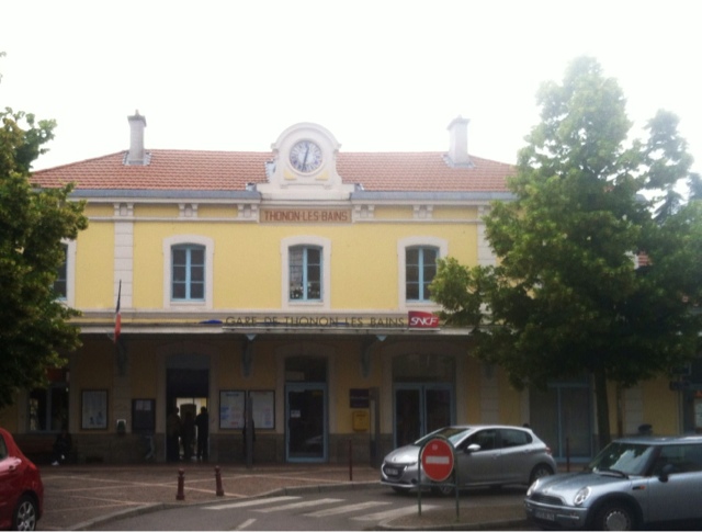
The trail was well marked until a crossroads in the forest, but balissage was completely missing after that. Still, we did fairly well using map and compass until we were nearly at Armoy. There, however, we got completely turned round (without knowing it), and unaccountably circled back, always in forest frequently quite muddy, until we finally came out onto a paved road at a sign reading — Thonon-les-Bains! We were back where we'd started, even a little west of where we'd started, further than ever from GR5, after three hours of sometimes hard walking, probably seven or eight miles.

The good thing was that there was a spiffy country highwayside bistro handy, where we had salades Savoyarde and a liter and a half of Badoit rouge. I phoned a chambres d'hote in Chevenoz, where the day's hike should have taken us, and reserved a room and dinner for the night; then we walked back into town. At a bus stop by the hospital I asked a young woman about a bus to Chevenoz, and she told me to take the bus she was getting on, go to its terminus at the Place des Arts in Thonon, and buy tickets there for the bus to Chevenoz. 

The ticket-selling woman at the bus counter was also very helpful. When I wondered if there were a bar or café at Chevenoz she refused to sell us tickets until the bus came in, so she could ask the driver. He said there was, though he was unsure if it were open, so we hurriedly bought the tickets and climbed in. 

There were only two other passengers, both very young women who kept up a steady conversation with the driver all the long and twisty road. We left Thonon at 3:15, heading first toward Evian, then turning off and climbing to St. Paul toward Bernex, then turning down into the Abondance valley, arriving at Chevenoz about 4 pm. 

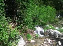
Chevenoz is a church, a school, and a bar-cafe (closed today), little more. I noticed a sign advertising our chambres d'hote and we walked a quarter mile down toward the stream to it, encountering a couple in their sixties toiling up the road; they assured us our gite was just ahead of us. We found a chalet with vive guest rooms, an old Savoyard barn, lawn, and little lettuce patches. It is very beautiful here. The weather changed fast just after we arrived, from clear, hot, and a little humid to thunder, lightning, and hail the size of golf balls.

Our room is on the top (second) floor, with a double bed, a single bed, our own bath, and windows looking out toward the imposing crest we will climb tomorrow, weather permitting. Below us, four double rooms. Rez de chausée, sitting room, dining room, kitchen, and I suppose the rooms of the owners. 

Our dinner companions are a Dutch couple from den Bosch, talkative and interesting, fluent in English, in their early sixties I would guess, fit and athletic. They have done considerable mountaineering, the last two weeks on the Italian side based around Courmeyer. Dinner was, first, grated carrots with a hint of coriander, cinnamon, and orange sections; then fondue with bread, ham, sausage; dessert was a smetana-like substance with huckleberries. Red and white wine en pichet. 


Then to bed — but not before a magnificent sunset lighting up half the surrounding mountains. We are quite in the countryside, fragrant and alive: quite a contrast with airports, bus stations, city types!

What to do tomorrow? We can sleep  after a long hard walk at Bise, but it is unattended and we are not really provisioned. Or shall we take a bus to Bernex and stay in a hotel? Seems like cheating. Or climb to Dent d'Oche with our Dutch friends? Or simply bite the bullet and face a long day to La Chapelle? Well, we'll look at the weather and decide…

Alps, 2013, 1: Thonon les Bains


Thonon les Bains, June 20, 2013

After a long flight, San Francisco-Chicago-Philadelphia-Frankfort-Geneva, complicated by late planes and therefore missed connections, we finally flew into Geneva, Mont Blanc welcoming us through the windows on the left side of the airplane, at five p'clock, but where are our bags? Oh: on a different belt, for some reason.

We take the nominally free train into the city, paying for it necause we bought the tickets just outside the airport, and then tried to find the bus station for our bus into Thonon les Bains. I ask a seedy- looking guy for directions, then disbelieve him because he contradicts advice I'd heard from others, and he is indignant; we search further asking people in a dubious district full of plump scantily dressed women lounging at street corners in heavy makeup. 

Finally we find the station, buy tickets of another seedy fellow who is negotiating with a Bulgarian truck driver who wants to park in the bus lot,and get on our bus. Where to get off? I ask about this of many other passengers and the coductrice driving the bus, eliciting considerable discussion. Finally we get off, with an Algerian who had reserved the same hotel on Bookings.com just before me.

This is one of those unattended residence-hotels: the blackboard welcomes us and directs us to our various rooms, where we find a key. We shower, change, and go to the first and only eatery we find still open. a Mexican joint, pleasant, amusing, and relaxing. By night the town is quite beautiful, mysterious, entrancing; or it is perhaps our fatigue, and our uncertainty about tomorrow. 


 Restaurant, Thonon les Bains

Then back to our hotel, where we share the double bed quite chastely. When making the reservation I'd requested two beds, but you don't always get what you ask for.

Thursday, June 13, 2013

The Mt. Whitney Expedition — 2: Descent

June 8, 2013: Trail Camp - Whitney Portal; 6 miles; ca. 4 hours; down 4,000 feet.
Whitney Portal - Bishop by car, 69 miles; ca. 1 hour 30 minutes.
dawn.jpg
Trail Camp, 5:00 am
AWAKENED AT 3:30 by the others, who were getting ready for their breakfast and an early start for the summit, I found I had a headache — unusual for me. And it was generalized: it felt as if my skull were slightly too small for my brain, which surely can't be the case. Altitude; no doubt about it. I dozed while they fixed their breakfasts. At 4.30 I finally decided against the summit climb, for three reasons: I would slow the others down; I would be adding nearly ten miles and 5,000 feet of elevation change to the six miles and 4,000 feet (down, it's true) that I had to do today anyway; and I didn't really want to do it. Something of the same thing happened last September, when I attempted Mt. Shasta, a more difficult ascent though a somewhat lower summit. Again, I was with two dear friends (not to say close relatives); again, I was concerned that I would slow them down. It is a very interesting thing about summits, in my opinion, at my present state: I feel they will always be there; I'll always, or at least sometime perhaps, have another shot at them. On my terms: which means, taking plenty of time. They set off at 4:30; I dozed another hour. At about 5:30 I woke up completely, sun breaking through the rear window of my tent, oriented toward the east. Nico was stirring: having summitted the day before, he had nothing to do but break down his tent, pack up, and hit the trail for Whitney Portal. He didn't even wait for breakfast: he'd get a proper one when he hit Lone Pine. I broke camp along with him, and left Trail Camp at 6.22, carefully checking the time — I was curious as to how long the descent would take. My pack was hardly heavier than it had been on the ascent, even though I was now carrying my tent and sleeping pad. sunburst.jpg 
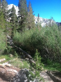
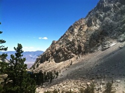
Descending is quite different from ascending. Your eye more easily lifts toward the distance, even though the terrain is just as irregular as yesterday's. The known is easier than the unknown, whether or not you're apprehensive about anything. I knew the structure of the hike: Trail Camp the departure; Trailside Meadow where camping was not allowed; Mirror Lake; Outpost Camp; Lone Pine Lake which really seems to me more a marsh; the sign marking the wilderness area boundary. The creek where Simon remembered the permit, and turned back. The trail is about two-thirds steps, on granite stones of various heights, requiring a certain amount of attention, and facilitated by the use of trekking poles. These are generally on switchbacks, though there are occasional straight stretches. A more welcome third of the trail is sand, dirt, or very fine scree, and here, whether switchbacking or not, I put the poles away for the most part, hoisting them nonchalantly behind me since there's no one there to threaten; or simply carrying them both in my left hand, swinging my right for balance, or tugging at the chest-strap of my pack.
yellowflowers.jpg redflowers.jpg
Along the way there was the occasional patch of flowers — columbines, as I thought; buttercups, I think; very nice red flowers that made me think of Indian paintbrush and owl's clover though they were clearly neither. I really must learn to identify these things. There was even one ranunculus, I'm sure of it; I didn't photograph it, but I recall it clearly; it looked just like the ones we've seen in the Italian alps. Finally I arrived at Lone Pine Lake: the trail was clearly less austere and rocky, more welcoming, moister. At one point there's a succession of logs you walk on to cross a wide marshy area; logs perhaps ten feet long, flattened on the top about nine inches wide, and set Lincoln-log-style on shorter transverse logs, perhaps two feet above the shallow water and its stone-covered bed. I'm glad my pack is snug on my back, nothing swinging. I hold the poles out from my sides, keep my eye on the end of each log, and set out fairly confidently. At the end of each you have to take a long stride to plant your foot on the next, but there's not that much to it, really. bridge.jpg I arrived at Whitney Portal at 10.30, and after cleaning up a bit lost no time ordering breakfast: less than a quarter of a disgusting pancake, not quite done, over an inch thick, and a foot in diameter; delicious crisp bacon; a pint of raspberry-pomegranate drink; another of Gatorade; coffee; much water. At noon, a beer. Three men and two or three boys had taken up the next picnic table outside the Whitney Portal store, and I passed the time eavesdropping on their conversations. At one o'clock, lunch: bacon, lettuce, and tomato sandwich. How delicious to taste tomato and lettuce! The rest of my party showed up about 4.30, rather triumphant from their summitting, where they set a record, as they think, for highest cappuccino preparation — if a Moka pot can be said to produce caffe espresso. Now, though, they were ready for a beer. I didn't mind joining them: and then we drove to Bishop for the night: a nice hot shower, a change of clothes, dinner at Whiskey Creek Restaurant, and a good bed in a dodgy motel.
June 9, 2013, Sunday: Bishop - Healdsburg by car and bus, ca. 450 miles; ca. 9 hours
Up about eight; breakfast at a cafe in town, after looking at an unattractive "bakkerij" full of kitsch. (Come to think of it, Whiskey Creek was full of kitsch too, like Harris Ranch; but it didn't seem as offensive.) Then the long drive up to Reno, with fascinating conversation on the way — but conversation like that gets written about elsewhere, if at all. Lunch in Carson City after a short walkabout to see the splendid old capitol building, and a lazy coyote ambling across Main Street in the middle of town. Then on to Reno, arriving with twenty minutes to spare before boarding the bus for the ride back, through Sacramento, on to San Francisco, where Lindsey and Giovanna were waiting to take me out to dinner. It's a long way to drive for ten hours of hiking and two nights in a tent. But it was a fine weekend, and I'd do it again at the drop of a hat. Maybe three nights, so I can get to the top…
PavelMe.jpg
Pavel trailing me on a rare level stretch of trail above Mirror Lake
photo: Simon Zivny

Wednesday, June 12, 2013

The Mt. Whitney Expedition

June 5, 2013: Healdsburg - San Francisco - Sacramento - Reno by car and bus, ca. 290 miles; 5 hours 30 minutes. Truckee.jpg We drove to San Francisco where I was dropped off at the Caltrain station. Megabus to first Sacramento, then Reno. We left San Francisco about 4:45, the bus nearly full of Giants fans. WiFi sketchy on the bus, and altogether lacking after Sacramento, but a convenient power outlet in front of me. Most riders in a party mood; much conversation. 6:53 PM in Sacramento at train station. Woman next to me has moved upstairs the better "to see the view going over the hill." Outside, a guy is saying he couldn't buy a ticket online because the bus was sold out — good thing I bought mine yesterday! At 7:15 PM we left Sacramento. Man across aisle from me — got on in Sacramento — shaving his chin with handleless safety razor. 8:53 PM, Truckee, nearly dark now. Man shaving begins to exhibit Tourette's symptoms. At 9:45 we arrive in Reno, across the street from my hotel, the Circus Circus casino. Ham-"Swiss" on a soft roll, coleslaw, bath, and bed.
June 6, 2013: Reno - Whitney Portal by car, 275 miles; ca. 6 hours.
Whitney Portal campsite - Whitney Portal store, 1 mile round trip; ca. 20 minutes; up 500 feet, down 500 feet.
MonoLake.jpg WhitneyPortal.jpg
Mono Lake
Whitney Portal camp
Woke up about 545 in the morning after a good night's sleep, maybe 6 1/2 hours. Wrote home; then breakfast in Americana Café: eggs, bacon, pancakes, potatoes and toast. No wi-fi, though. Better get used to it. The hostess entered from the kitchen door, walked to the podium carrying something in her right hand and sneezing into her left, which she then wiped on her skirt, laughing. Pavel arrived with Simon and Jesus promptly at 7.45. We stopped in at The House of Bread, but were quite unimpressed with what we found (apart from the enthusiasm and generosity); then stopped at a nearby Starbuck's for the morning cappuccino. Then we drove south on Highway 395: Mono Lake; Bishop, Lone Pine. Lunch in Bishop: taquitos and salad at Artoga's, really very good. Another stop in Lone Pine in another hour, for coffee and bear canisters at a nice sporting-good shop; then drove up to Whitney Portal where made camp, dinner. After dinner we walked from our camp to the trailhead store, at 8360 feet, for mosquito repellant. Climber there gnarly, wicked; had been to Patagonia. To bed, 9:22; pulse 75. 7850 feet
June 7, 2013: Whitney Portal campsite - Trail Camp; 6.5 miles; 6 hours 20 minutes; up 4,150 feet (to 12,000). Happy Birthday, Lindsey! Up at five after a fitful night with a few half-awakenings, dreaming questions: what's Italian for "bat;" what was Mrs. Imamura's first name; shouldn't the American Civil War be called, not The War Between the States, but "The War of the Southern Secession." And, finally, in the gathering pre-dawn light, the dreamed sound of a telephone bell woke me for good.
Simon.jpg
Simon runs back for the permits
A cold night, too; tonight I will sleep in clothes. Also, awakened last night, almost immediately after first falling into a deep sleep, by the smell of smoke, then firelight, from a huge flare-up in a neighboring campground. And the, middle of night, a heavy truck toiling up the road from Lone Pine, its headlights finally sweeping tent wall. (This morning, a little after four, a skunk, peacefully poking around camp.) After walking about a bit, writing this, pulse is 63; not bad. We left Whitney Portal at 9:00 am. My pack was surprisingly light, only 24 pounds. At the first creek, Simon realized he didn't have our wilderniss permit, required for overnight campers on the Whitney trail. He apparently thought he had left it back in the car, so volunteered to go back for it. Pavel and I went on; Nico and Jesus waited for him. They caught up with us within half an hour.
creek.jpg timberline.jpg
The trail is strenuous but rewarding. There are surprising creek crossings, fine if thin forest, and amazing boulders along the way. Before long we crossed the timberline, and distant vistas opened out to us, sometimes east across Lone Pine, a mile lower and fifteen miles at least away, toward the White Mountains. trailcamp.jpg
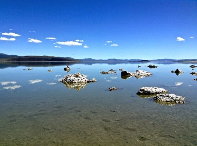
We arrived at Trail Camp, a nice site at 12,000 feet, at 3:20 after a strenuous hike, leaving me leg-weary and frequently winded. Nico was going to have to leave first thing in the morning, when the rest of us planned to summit, so he headed off for the top alone, leaving before the rest of us arrived. The others went down to the lake for water, which they filtered and treated with their sterilizing pens. Before long I discovered why my pack had been so light -- someone had removed my tent and sleeping pad from my pack, carrying them himself! Very sneaky, but very generous: these guys are bending over backward to put up with a companion pushing eighty. While they were off on their errands I struck up a short conversation with our neighbors, who'd set up tents at the next site, maybe thirty yards away from ours. From Poland, they were nice young people, two couples and a couple of children. I had freeze-dried beef stew for dinner, and it wasn't bad, but I couldn't eat all of it. Then it was time for post-dinner duties, and then to bed, quarter to eight and the daylight quite gone, my heart ticking fast for me at 84 beats per minute. The others stayed up until close to ten, keeping me half-awake in a companionable way; but soon they were all snug in the tents, three of them for the five of us, and a cold dark night drew around us, with brilliant stars overhead.

Tuesday, June 4, 2013

Ready…

boots.jpg
Eastside Road, June 4, 2013—
SPENT MUCH OF the morning getting ready. Nikwaxed the boots, the lovely Vasques, which have walked from Lake Geneva to Nice, from Sausalito to Half Moon Bay, and innumerable day-hikes around Sonoma county, and look to have plenty of miles left in them. Found nearly all the paraphernalia: the tent and foam mattress in storage, where they've been since last September's assault on Mt. Shasta. The sleeping bag and the wonderful silk sleeping sack up in the loft. In the old camping box, unused for at least fifteen years, the little camp stove and a half can of propane for it — it fired right up. Most satisfactory. Out shopping, then, for the disgusting food, freeze-dried pouches of beef stew and eggs with bacon, and a half dozen Clif bars, and walnuts and dried apricots. And the few odds and ends still missing: a whistle, a match safe. The backpack, packed, runs to over thirty-two pounds, which is too much. (The shoes weigh a kilogram apiece.) And tomorrow is going to be an odd day — but I'll face it tomorrow, if you don't mind…

Sunday, June 2, 2013

Mt. Taylor

steep.jpg
Eastside Road, June 2, 2013—
SHORT AND STEEP today, out at a new local park, Mt. Taylor. Well, it's not really much of a Mount: we only got up to just short of 400 meters, about 1300 feet. But my new iPhone app tells me it was a ten percent grade overall, and much of the trail cuts across the contours, going straight up the hill. It didn't stop the guy you see here at the top, who rode his trail bike all the way up. About four miles altogether, with stunning views, if you like subdivisions and warehouses… • Taylor Mountain Regional Park, Kawana Terrace, Santa Rosa, Californiadistance.jpg